New Product Release | DV-LiDAR600 New Generation Medium-Range Lidar Payload
Currently, there are two main types of UAV airborne lidar. One is a short-range laser of about 250m, which is low-cost, short-range, and suitable for small-scale terrain data acquisition. The other is a long-range laser of 1500m and above, which is heavy. Large, high cost, suitable for large-scale terrain data acquisition for large models. The successful development of DV-LiDAR600 has filled the gap in lightweight medium-range lidar. The device has a total weight of 2345g and a maximum range of 1000m. It can be mounted on the V10/D20/D500 intelligent drone system for efficient operations. DV-LiDAR600 integrates a full-frame camera module and uses a 28mm focal length aspherical lens to acquire orthophoto data with appropriate resolution while collecting laser data.
Medium and Long-distance Measurement, High Point Frequency
Lightweight radar body, laser ranging up to 1000m; real-time full waveform processing algorithm, capable of 1000kHz measurement frequency and unlimited echo resolution: laser point frequency is continuously settable, equipped with 9 optional gears for easy control use.
The laser repeatable ranging accuracy is 3mm. It integrates a high-precision MEMS inertial navigation system and uses expert-level point cloud processing and optimization algorithms to ensure the quality of point cloud data. The result accuracy can achieve a medium error of 5cm at an altitude of 200m. The laser divergence angle is 0.35mrad, which makes the laser energy more focused on details and performs better, effectively ensuring the point cloud effect and accuracy.
100° laser field of view, wider point cloud coverage in a single flight belt, more efficient operation, downward opening design, 100% point cloud utilization, relying on ground-imitating flight technology to ensure a more uniform point density and maximize the point frequency effect , to achieve higher point density.
Adaptive radar speed point cloud distribution is more even
Uneven point cloud distribution not only affects the aesthetics of the results, but also affects the accuracy of the terrain representation. It is estimated through parameters such as point frequency, flight altitude, and speed. The software adaptively sets the radar speed according to the measurement area to ensure uniform point cloud distribution.
Professional surveying lens
It integrates a 42-megapixel full-frame camera and uses an aspherical lens for orthophoto mapping, with distortion less than 1%. , to ensure clear image quality and improve the accuracy of results; the lens focal length is 28mm, and appropriate resolution images can be obtained at typical altitudes, such as 5.4cm resolution images at an altitude of 300m.
The DV-LiDAR600 has a total weight of 2345g and can be mounted on the D500 intelligent drone system for operations, reducing field operations and transportation costs and providing customers with more choices.
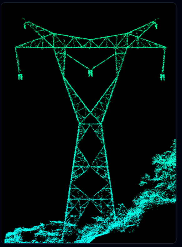
Mountain terrain data acquisition solution
Acquisition of mountainous terrain data is still the primary application scenario for UAV airborne lidar systems. In this scenario, both the composite wing and rotor platform of Pegasus can be used to fly on the ground, and the DV-LiDAR600 has unlimited returns without fear of high-drop terrain. Wave capability, its laser spot is small, the energy is concentrated, and it has strong penetrating performance for mountainous vegetation. In this plan, a D500 flight platform is used to mount a DV-LiDAR600 payload, with a flight height of 200m above the ground. It was carried out in a mountainous area in Guangdong in July. Terrain data collection.
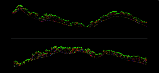
In the mountainous areas of Guangdong in summer, vegetation can still be easily penetrated. The following figure shows the penetration performance, point cloud data before and after filtering, and the results.
High-Precision Measurement Solutions
DV-LiDAR600 has a maximum point frequency of up to 1000kHz. With an excellent performance flight platform, it can safely fly at low altitudes or accurately imitate the ground. It can implement high-precision and high-point density operations for industries such as railways, highways, and smart transportation. plan. The D500 flying platform is used to mount the DV-LiDAR600 for 65m altitude operations. The flight speed is 8m/s, the average point density is 3200pts/m2, and the average point cloud thickness is 1cm. The details of the ground objects in the result data are clear, and the absolute accuracy can be achieved after further strengthening the control. Less than 2cm.
The point cloud density on both sides of the road and the road surface in the video is high, and the data restoration level is close to the vehicle level.
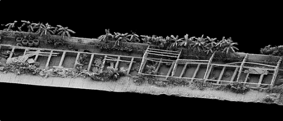
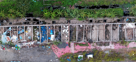
The picture below is a rendering of an abandoned fish pond in the case data. Steel pipes, wooden bars, buckets and other objects stacked in the site are clearly visible. At the same time, 1cm resolution orthophotos can be obtained at this altitude.
Digital Solutions
With the advancement of real-life 3D construction in China, there are an increasing number of digital digital city projects. DV-LiDAR600 can easily handle digital digital data acquisition due to its high point frequency, high definition, and high accuracy. In this plan, D500 is used to mount DV-LiDAR600, the flight altitude is 200m, the average point density is 200pts/m2, control points are laid out in the site, and the error in point cloud elevation is checked to be 3.2cm.
